A Study of Stephen F. Austin’s 1829 Map
By Raymond. V. Carter, Jr.
Copyright 2022
It is David Lewis’s theory that the 1831 Bowie San Saba mining exploration trip approached the mission and presidio locations on the Rio San Sabá from the east, after exploring the Los Almagres or Pack Saddle Mtn. region. I too, believe that the Bowie group approached the Menard area from the east. This is evident from Jim Bowie’s statements made in the 1831 report to Political Chief Ramón Músquiz. It is also my belief that James Bowie used one of Stephen F. Austin’s maps (specifically the 1829 map) to guide them during their exploration and prospecting. Bowie also had many sources to influence him, the prominent Spanish and Mexcian Don’s and pioneer families of old Bejar.
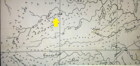
Carefully examining Austin’s 1829 map, one will notice that the “i’s” in all the words, Rio, Lomrillos, Palisade, and Lucia, are dotted. It may also be noted that the “springs,” (fuentes) are clearly marked with dots. This was a deliberate and careful notation by Austin. What caught my eye was the dot Austin made below the “de” at the notation “mina de plata” south of the Rio San Saba on his map. There are no other dots in that area, and it appears to be deliberate. This marks the silver mine his “mina de plata” eludes to. This is pointed to by the arrow I inserted in the picture of Austin’s map.
This could be “a” mine or one of the “silver mines” that the Bowies were searching for and one of the reasons they were approaching form the east. You must understand that the main San Sabá road came from the east and north of the Guadalupe River and the carretera secundaria de la Bandera (minor road) came from the south around the west side or headwaters of the Guadalupe River. But, it was this minor road that the Bowie party left Bejar from.
Agreeing with David Lewis’s theory, it is also my opinion that the Bowie party approached the Menard/San Saba region from the east. I believe the Bowie party first came upon the old mission site. Possibly, some of the old wooden structures of the mission that other explorers might have used after the destruction may have still been standing??? I have personally owned and discovered wooden log cabins well over a 100 years old, one in 1961 and two others still standing in the 1990s. It is my opinion they arrived there late, forded the Rio San Saba and rode just north of there and made their camp and the next morning had their fight with the Indians that were pursuing them—the so called “Calf Creek Fight.” There is a hill, a creek, etc., that could meet the description the Bowies laid out in their reports. This theory is a main project of exploration of the future research to be done by David Lewis and I.
Image courtesy of the Texas State Library Archives.
Ray Carter wrote this article. His author page and a link to purchase his book on this subject and others click here