The Packsaddle Rock Walls: Fences or Markers?
David C Lewis wrote this article. His author page and a link to purchase his book on the San Saba Treasure is here
Archaeologists who have visited the Stotts Ranch at Packsaddle Mountain, in Llano County Texas, were mostly interested in the mine shafts on the property. The question was how old are the mines, did they date back to the Spanish Colonial period, and could they even be the Los Almagres Mines described by Miranda in 1756? Occasionally a passing remark is paid to some stone walls uphill from the shafts. Walls, must have been where livestock was kept.
But in 2020 Ray Carter, an author and amateur historian like myself, met with Joe R. Wallace. Wallace described the mines on the Stotts Ranch. I had heard of the mines, had read everything I could get about the mines, including the book by James Stotts himself. Something new from talking to Wallace was that he thought that the rock walls were not fences of any sort, but were rather markers of a fashion.
In 2022, on a very hot summer day, I met Carter on the Stotts ranch to look at the rock walls first hand. Carter had formed a lasting friendship with James Stotts and we were welcome to see what history we might pry from the ground.
The walls are there, but could hardly be called walls, with them only being a few feet high at most. Maybe effective at corralling Corgis or Dachshunds, but few other domesticated animals. As well, the walls started on a rock face and projected downhill in straight lines. There were no walls further down that intersected with those walls to make any sort of pen. So even Corgis and Dachshunds could have gotten out just by walking downhill. I could not see any evidence of the walls once being taller and having toppled over. It was looking like Wallace was on to something.
So what could they be? Wallace thought they were markers. If so, what did they mark? Or perhaps, what did they point to? That summer day in 2022 with GPS and compass in hand the terminal point of each wall, closest to the rock face was established and then a compass reading was taken, sighting down the length of each wall. The compass directions adjusted were for magnetic declination.
The following map shows the plot of each wall, and where they point. Between the projections from walls #1 and #3 sits the “Tick Mine,” an acknowledged Spanish Era mine (#8 on the map). The only feature between the lines projected from those walls.
Wall #4 projects one way, then takes a turn, which will be called wall #5. Between the projections of wall #2 and wall #5 sites four prospect pits, all thought to be of Spanish Era. There is also the remains of a small smelter, thought to be from the late 1800’s, and one shaft (#9 on the map) goes straight down. That shaft may have been dug in 1868 by a W.G. Cheenie, but it is possible that Cheenie, as most Anglo miners in that era, took up where the Spaniards had left off.
Between the projection of walls #4 and #5 is one prospect, thought to be of the Spanish era. The last feature in this area is one mine (#10 on the map) that is of Spanish era, but later worked by the Anglos. That mine is to the east of the eastern-most projection of wall #4.
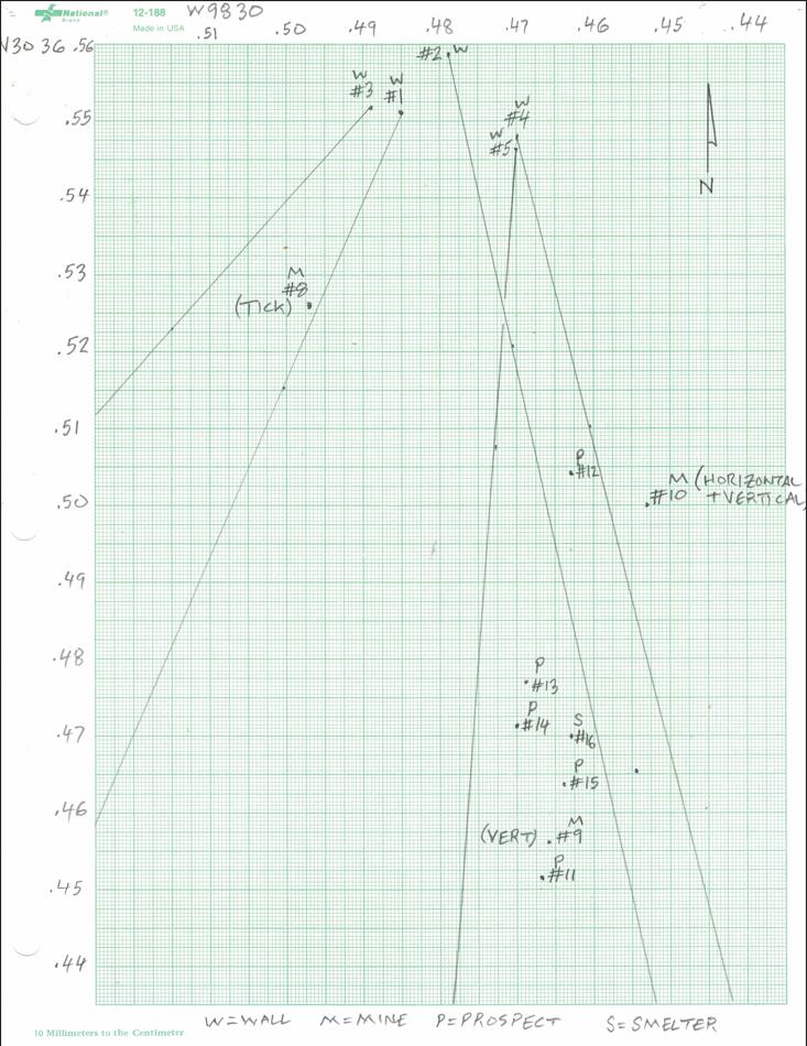
It is proposed, as neatly as most of the mines and prospects sit between the lines projected downwards from the walls, the otherwise random and useless nature of the walls as fences, that the walls were used to delineate mining claims, or perhaps the rights to work portions of mining claims. If the heavy brush now on the mountain did not exist in the Spanish era, then this would make some sense. Stakes could be moved. Trees might burn down. But rocks walls such as these would take time and effort to reorient, and leave behind strips of dead grass. Perhaps the Spaniards with mining claims would visit, go to the area of the rock walls, and at a glance see who might be encroaching on the area of their claims.
If that was the case, Wallace was right. And it would also imply that there were multiple mining claims active in the same time period in the Spanish era on that plot of land near Packsaddle Mountain.
David C Lewis wrote this article. His author page and a link to purchase his book on the San Saba Treasure is here